SUPER HURRICANE MILTON’S WINDS ALMOST KNOCKED OVER A PLANE WITH 50 YEARS OF STORM FLYING EXPERIENCE, 4.5M HIGH TSUNAMI FORECAST
The US National Hurricane Center (NHC) announced that Hurricane Milton has weakened to a Category 3 storm on the Saffir-Simpson hurricane scale but is still a strong storm.
ABC News reported that Hurricane Milton made landfall on the west coast of Florida at 8:30 p.m. on October 9 (local time, or 7:30 a.m. this morning, October 10, Vietnam time) as a Category 3 storm with winds of 120 mph.
Previous forecasts said that Hurricane Milton would make landfall as a Category 4 storm.
Although the storm has weakened to a Category 3, the storm is increasing in size and will still be an “extremely dangerous major hurricane,” according to Reuters.
NHC said that as of 5:00 p.m. on October 9 (local time), Hurricane Milton was approaching Florida, only 275 km southwest of Orlando, with winds near the storm’s center at 120 mph.
The NHC forecasts “a potential for some variation in intensity as Milton moves across the eastern Gulf of Mexico, but Milton is expected to be a dangerous major hurricane by the time it reaches the coast of central Florida.”

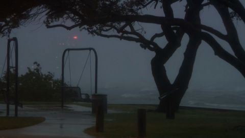
Winds and rain in Bradenton, Florida, on Oct. 9. Photo: CNN

Strong waves hit the coast of Tampa, Florida, on October 9. Photo: CNN
Bringing rain and strong winds across the region, Milton also spawned a series of “supercells” (a type of extremely powerful, complex storm that can produce tornadoes) that swept across southern Florida.
The National Weather Service in Miami observed at least four tornadoes, including a “multi-loop tornado,” early in the afternoon, as meteorologists reported storm surges beginning to move in along Florida’s southwest coast.
As a result, tornado warnings and hurricane warnings were issued for several cities in conjunction with hurricane and storm surge warnings already issued for several locations.

A home in Fort Myers, Fla., damaged by tornadoes from Hurricane Milton. Photo: Reuters
A hurricane warning is in effect for Florida’s west coast from Bonita Beach north to the Suwannee River, including Tampa Bay, and the state’s east coast from the St. Lucie-Martin county line north to Ponte Vedra Beach.
The threat of storm surge is a major concern for Florida’s west coast. In addition to the hurricane warning, a storm surge warning is in effect from Flamingo north to Yankeetown, including Port Charlotte and Tampa Bay. A storm surge warning is also in effect for Florida’s east coast.
High waves are also being reported in southwest Florida. Some areas are expected to see waves higher than 10 feet (3 m) overnight on October 9. The National Oceanic and Atmospheric Administration (NOAA) is forecasting a wave higher than 28 feet (8.5 m) near the center of the storm.
Hurricane Milton could bring a storm surge of 9 to 14 feet (2.7 to 4 m) in many areas and bring rainfall of 6 to 12 inches (150 to 300 mm). Some areas could even see up to 18 inches (450 mm) of rain.
Hurricane Milton is expected to maintain its intensity as it moves across the Florida peninsula and threaten other states on the East Coast.
As Hurricane Milton approaches Florida, forecasters are also concerned about the possibility of a new storm forming in the Atlantic. According to the US National Hurricane Center, the agency is monitoring three other systems in the Atlantic, which could form a new storm in the next 48 hours.


